Want to see BlurbBits in action? Visit our Sailing Blog or more examples.

2008-12-23

Picasa - Remote Photo Editing

We love traveling to remote places, taking lots of pictures and sharing our experiences through our Blogs. One of our main issues is the lack of internet access because most photo sharing sites force you to make collections and albums online.

Picasa is great because you can add captions and tags, edit and organize your photos into albums all without internet access. You can even Geotag your Picasa photos in Google Earth while it is offline. Then once you find an internet connection you can upload your photos to your Picasa Web Albums and easily turn them into BlurbBit Albums that you can add to your Blog Posts.

Picasa is really two tools, Picasa which lives on your local computer (and manipulates your local photos) and Picasa Web Albums which manages photos you choose to upload and share on the web (BlurbBits uses these). Note: BlurbBit references to Picasa relate to the shared web albums.

Upload via Direct Internet Connection

If we have a direct Internet connection we use Picasa Upload (from your computer).
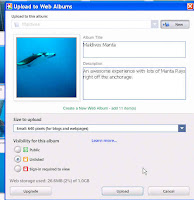
Choose or Create an Album, Select the Image size. Since we usually only use the photos for our blog, we use the small size to save space and prevent printing of our photos.

Upload at Internet Cafe

If we don't have direct access, we use Picasa Export to save the selected photos to a new folder.
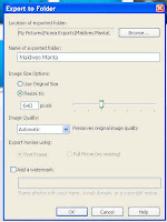


Then we copy the directory to a USB stick. Once you are at the internet Cafe, Log onto Web Albums and use the Upload button. Select or create a new album and add the files from your stick, it's a little slower this way but sometimes it beats lugging your computer to the Cafe.
If you use Flickr or another photo sharing site, use Picasa Export to save the selected photos to a new folder. Upload the photos from the new folder using your sites uploading instructions.

MoBlogging and Photo Maps

Picasa Web Albums supports email upload or you can use Blogger to upload your blog text and photos from a remote location. Check out the details here.

Photo Album and Map

Once an album is uploaded you can map the photo albums. This is much easier than geotagging ALL your individual photos (we support both). We also make it easy to build a BlurbBit (w/Map + Photos) using the BlurbBits Mapr. If you add the resulting BlurbBit to a blog post, we use it to determine the posts location. Once we have the posts location we can map that too, all that from a single mapped Picasa Album!! If you add/modify the photos or change captions/notes to photos in the album, all the changes will appear in the BlurbBit automatically.

Note: the same process can be used remotely with any non-web based photo editing tool that saves Exif data (like Adobe Photoshop Lightroom) . Test a couple of photos (raw vs jpeg) to make sure you have complete data (captions and geotags) before going too crazy. We do need the photos online (Picasa or Flickr) to gain access to them. Picasa has good synchronization between your photos on the PC and the Web Albums.

MoBlogging - Blogger on the Go


Update: We are also reviewing
posterous for remote email blogging AND photo sharing. Posterous' focus is "dead simple" blogging via email. Blogger's email functionality is very limited and support/updates to the email method are non-existent.

Sometimes you want to blog but you can't access the internet directly (i.e you're in the middle of the ocean 1000 of miles from the nearest Internet Cafe).


Blogger has two methods to support moblogging which can be used to add text, a small photo, or both (hey I didn't make up the term).
Geo MoBlog Photo Maps

Note: this section is mostly applicable to Blogger-Mobile users who take photos with a GPS enabled device and want to map their tracks through photos NOT blog post content.

If your photos are geotagged (either manually or via a geotagging enabled phone) you can easily create a photo based map of your travels. When images are uploaded to Blogger, an album is automatically created in Picasa Web Albums. Go there, find your Blogs Album and click on the link (notice the AuthKey in the URL you'll need that).

In the examples below, use the i (Info) button to view the embedding options. Use the Blogger AddGadget button to add to the sidebar and the BlogThis button to add to as a new post. Adjust the &width and &height to match your blog layout size and usage (sidebar vs post).

Interactive Examples:
&picasa=SailBillabong:IndianOceanPictures&pm=1&width=220&height=200&mark=smallred&smark=smallred
Our Indian Ocean Photos Mapped
&picasa=SailBillabong:IndianOceanPictures:start-index=10&pm=1&width=220&height=200&mark=smallred&smark=smallred
Skip the first 10 photos from our Photos Above.
&picasa=SailBillabong:IndianOceanPictures:start-index=10
Show the Album Photos to find the correct start-index.
&picasa=SailBillabong:Sailing2007&pm=1&mark=midredx&smark=smallred&width=220&height=200
The Sailing2007 map from SailBillabong (try Sailing2004, Sailing2005, Sailing2006). The X mark represents the end of the year location
&picasa=SailBillabong:BillabongAtSea:authkey=VtVRMtCavYI&pm=1&width=220&height=200&mark=smallorange
The BloggerAtSea Blog Album map. Unpublished Albums require AuthKey shown in Album Url

Picasa orders their feeds starting with the first photo taken, so you may need to adjust the start-index to focus on a certain portion of the trip. Leave off the &pm=1 and make sure you are starting with the correct photo. Once you have completed a trip you can copy a set of photos into a new Album which details the trip. Do not move or delete the photos, they will be removed from the Blog post.

I have already seen photo blogs dedicated only to geotagged photos for tracking purposes. The photos are usually horrible quality and the posts don't include text, which in my mind is pretty much a completely useless Blog. If you are only using photos to track your travels it makes more sense to use Picasas email upload.

Picasa Email Upload

Picasa also supports email upload of photos and you can place them into specific albums by using an existing album name as the email subject. If your mobile device supports geotagging you can easily get a map of just that album using the method above, use the album name to differentiate various trips. You can even highlight your favorite photos in a BlurbbBits photo album in a Blog post about your trip.

Interactive Travel Photo Maps

You can even use the same data to build an interactive map by using the same URL parameters with the BlurbsViewr.

Here's the BlurbsViewr map for our Indian Ocean Pictures (?picasa=SailBillabong:IndianOceanPictures).

If your photos are taken sequentially along your travel path you can add &tt=travel&mi=out to the URL to create a Travel Tracking Path with a calculated total distance - (select Trip Summary from the list in the upper right).

Extracting geotagged data

If you have a GPS Enabled phone or an automatic method for geotagging your photos, the location data you need is already hidden inside it. You can easily extract the Lat/Lng data using the BlurbBits Mapr and then use it to geotag your blog posts.

Here's the Indian Ocean Pictures. Click on sidebar list to navigate/zoom to a photo. The Center Lat,Lng,Z: field is the Lat/Lng and zoom of the photo location. Use the first two fields for the Lat/Lng in the Blogger-in-draft location editor to geotag the Blogger post (don't forget to remove the comma).

You can also use mapr to add a BlurbBit map of this location into your blog post. If you are using the non draft version of Blogger, this also allows the blog post to be mapped.

2008-12-18

Migrating Lat/Lng to Blogger Geotags

I have been following Blogger's announcement Blogger in Draft: New feature: Geotagging and noticed that some users are having a hard time finding their exact post locations. I have also seen various informal "geotagging" techniques used around various Blogger sites; Google Maps, Google Static maps, KML/KMZ files or text input and all geotagged photos contain the lat/lng data within the Exif data. All of these methods require knowledge of the exact Lat/Long for the marker (ie. post location). Since all of our Sailing Blogs are tagged with Lat/Lng, I thought I'd detail the migration path.

Blogger-in-Draft Location Editor


Enter a space separated Lat Lng pair into the search box of the Blogger-in-Draft location editor and click Search. This will zoom the map to the correct location but leave the Location link name blank. Zoom out (using the - button), the Location link name should now appear.

Adjusting the Location String

The Location string is determined via the reverse geocoder which will sometimes result in Unknown Location. You can adjust the Location name by clicking on the Location Link under the search box (next to Location:) and entering the desired Location text.

When I first tested direct lat/lng entry it didn't appear to work correctly (user error? Bug Fix?). Sometimes the result would shift back to the reverse geocoded result instead of the Lat/Lng in the search string.

Finding a Lat/Lng

There are lots of ways to get the Lat/Lng of a location/address including Wikipedia (good for tourist locations) or by extracting the data from geotagged photos (from a mobile device or automatic geotagging software).

2008-12-12

Dynamic Blogger GeoBlog Maps

Since Blogger-in-Draft announced geotagging support, we thought we would add some quick maps to highlight blog posts locations. This gadget locates the geotagged posts on each blog page and adds a link next to the new location footer or at the top of the post for other BlurbBit/text tagging methods. Update: now it does even more (expandable posts, popup maps/photos).


Clicking on the link will display a BlurbBits map directly on the page within Blogger (i.e. no new windows/tabs for your readers to get lost on). If geotagged posts are found, they are also added to a Geo-Blogs on this Page summary map. This map will dynamically change based on the page content and is very helpful for visualizing the locations of posts filtered via searches, labels or archives. Visit our Sailing Blog for a Blogger example (with zoom level definition) or check out our Map your Blogs playground for a Blogger-in-Draft example.

With geoblogs on this page summary map

Click to Add (Blogger post location version)

Click to Add (lat/lng text version)

Without geoblogs summary map(popups only)

Click to Add (Blogger post location version)

Click to Add (lat/lng text version)

This gadget is only supported with Blogger layout templates (the default), contact us to migrate your old or custom non-standard template blogs.

Interactive Maps (non-sidebar maps)

Check out the BlurbsViewr navigation map for a great way to navigate your blogs from a persistent interactive map. We even have specific Blogger mapping options to add an interactive map button (and more).

Adjusting your dynamic maps

Edit the HTML/Javascript Gadget
  • Use pw and ph options to adjust the width and height of the resulting map popup.
    zooms is used to adjust the zoom levels for the resulting map (in and out).
  • Adjust the size of the Geo Blogs map via the "geomap" width and height style parameters.
    We also use it's background-color to customize the popup.
    Most other options are explained in the Customizing a BlurbBits map section. We will be expanding the documentation in the near future.

    Refreshing your Browser

    During the testing/modification of your blog posts and gadget it is necessary to refresh your browser to get the latest available data.

    Refreshing your Browser in Firefox
    • Press the shift key on your keyboard and keep it held down.
    • Click reload on Firefox's graphical toolbar menu.
    • Keep your finger on the shift key until you see the page reload.
    Refreshing your Browser in Internet Explorer
    • Press the shift key on your keyboard and keep it held down.
    • Select view from the Internet Explorer file menu and click refresh .
    • Keep your finger on the shift key until you see the page reload.

    New Geotagged Blogger Posts


    We've been geo-blogging with Blogger ever since the second post of our Sailing blog back in June 2005. It is such a great way to track our travels and keep people up to date with not only what we are up to, but where we are. Most of our friends and family had no idea where Kiribati, Eritrea or the Maldives are, let alone the remote anchorages we love to visit.

    Blogger has just announced support for geotagging which is currently available only through Blogger in draft. This feature allows users to specify a location for each blog post and outputs it as a GeoRSS feed. Check out the announcement for some known issues.

    We have updated BlurbBits to support the Blogger GeoRSS output in addition to our existing text (for Mail-to-Blogger) and BlurbBit (including optional zoom and path) geotagging formats . This will allow users to view their geotagged posts in the BlurbsViewr (an enhanced blogmap) and/or extract various maps/views into stand alone BlurbBits.

    To learn more about BlurbBits start here or check out our basic BlurbsViewr Blogview.

    For Blogger viewing options with examples, check out our Blogger BlurbBits Playground.

    We are VERY excited about the new native Blogger Geotagging support and will be looking for additional ways to enhance your geo-blogging Blogger experience.

    Stay tuned for updates. Comments and feedback are always appreciated.