Benefits
Adding your location to a blog post makes it easy for other readers to discover the location you are describing. Other tools can extract this information and automatically build maps like on our sailing blog (both in-blog and interactive). Friends can see where you are and fellow cruisers will be able to use your blog as a personal cruising guide.
Blurbbits can extract a lat/lng position from the entry text or the first BlurbBit (with an llz position) and the first photo for each Blog entry . The text option is necessary when using email posting services which don't support html without rich text emails (not available through most remote email services).
Latitude and Longitude
The lat/lng text format is DD MM.MM[N|S] DDD MM.MM[E|W] (with no extra characters i.e. 36 17.63 N 30 08.98 E). The separator between lat/lng can be a space, comma or /.
example
Position: 36 17.63 N 30 08.98 E
Location: Finike, Turkey
adding the position: makes it easier to find blogs with position details via our Cruising Blogs Search
llz parameter
The llz= parameter can also be added as a string (llz=[-]DD.DDD,[-]DDD.DDD,Zoom i.e. llz=36.2938,30.1497,14) where - is used for South and West and zoom is optional but should be used if changing between remote locations (middle of ocean, zoom = 8) and street/anchorage maps (zoom=15). The zoom parameter is important if you want to highlight (or zoom in to) specific details.
example
Location: Finike, Turkey llz=36.2938,30.1497,14
Note: The lat/lng text MUST be on the same line with no Extra characters.
We have been extracting this data from text for a couple of years now and user error contributes to a LOT of inconsistencies and errors. Please double check your positions and text input (the llz= seems to be less error prone). If you are connected to the internet you can search and preview locations and zoom levels using the BlurbBits Mapr.
If you are describing an anchorage, a general description of the depth and holding including any important details about approach or shore facilities could help those following in your wake!!
Sharing options
Please consider sharing your favorite content on our community cruising blog and adding your blog to our Cruising Blogs Search engine.
Free Upgrade Options
When we first left we managed our own website and gradually migrated to blogs and online photo sharing utilities. Not only has this improved our ability to easily update our site (via email), but it provides online backup of our travel memories.
We use posterous and Blogger for blogs and Picasa and Flickr for photos (all are FREE) and provide additional sharing and mapping/viewing options via their RSS feeds. You can even update your facebook page (via your blog) from the middle of the Ocean.
In the end we combined all of our sites into a single interactive map that allows readers to navigate our online content via a persistent map. To see what others have done check out our examples.
Please Contact Us if you need help setting up your blog or mapping your existing content.
2009-02-05
New Dynamic GeoBlog Functionality
Update: The dynamic functionality is highly configurable for other options that allow javascript. Positions can be extracted from text and geo microformats. We easily configured it to provide maps for our Cruising Blogs Search.
We've been playing around with some new dynamic GeoBlog functionality to help further improve your blogs performance and flexibility.
BlurbBit links to dynamic popups
Now we can convert a BlurbBit link into a dynamic in blog popup. We search your blog page for BlurbBit links and dynamically change them into a popup version of the BlurbBit that opens on the same page.
- Any Map (Our Current location View BlurbBit w/Location)
The "original" link - unmodified View BlurbBit w/Location - From the Galley Blog Album (View BlurbBit)
use Notes (sidemenu) for a blog post summary
The same rules still apply.. the first BlurbBit will define the post's location. You can use either of the link publishing options, however make sure you don't use the (+Graphic) version before the first photo in the blog post. Don't worry we'll also add the
 (if it's missing) to help highlight it, you can even add them to the SideBar (check out our examples).
Expandable Post Summaries
Blogger has supported expandable post summaries for a while now. There are a couple of issues that prevented us from using them
- It only hides the rest of the post.
The page still loads any photos, slideshows, and BlurbBits even though the user can't see them (using display:none). Try adding a "broken" BlurbBit (make it point to a non existing album..) you'll still see the time out after 30 seconds, hmm.. not faster!! - You'll get "Read more.." even if there isn't any more!!
The "Read More" link always appears and if you don't use the <span class="fullpost"></span> within the post, you don't really get more when you click it. Since we publish our blogs via plain text email (where html formatting is impossible) this made it unusable with our blogs.
We also search the fullpost text for BlurbBits and add a popup map of the location to the summary page so you can see "where's that?" without requiring the full BlurbBit. This allows readers to preview the summary text and location map prior to clicking on the Read More link. We suggest you put slower loading content within the fullpost span so it will appear only on the Full page (after the reader is focused onto the page).
Check out our Sailing Blog for an example .. Not only do you get a faster loading, easier to navigate title page (and search/archive pages), it also helps you (as the blog designer) figure out exactly what content people are reading (see below). If you have your comment block set to , your readers will have a place to add comments immediately. You can even set up reactions to appear only on the post page.
Go to Dynamic GeoBlogs to add the Gadget which automatically supports both. You must follow the expandable post summaries instructions to enable expandable posts.
It's Unobtrusive
We use unobtrusive javascript to accomplish the above fuctionality. We quickly parse the document and modify the links into a custom designed popup. If javascript is disabled the links will remain a standard link, AND the standard links will appear in the feed (where javascript isn't available). You can also add a note to the Read More link so people will realize they are on their own if it is disabled!!
If you are manually adding BlurbBit links make sure you add class="blurbbit bblink" into your link so we can find what we are looking for without having to search EVERY link on the page, and don't forget the width and height parameters!!
What did they really read?
If you use Google Analytics you know that it can help track which pages people visit on your site/blog. One of the problems with blogs is the title page content continually changes. If people JUST read your main page you'll never really know exactly what they were reading. By adding the Summary posts and Read More links you'll get a much better content overview breakdown. We've highlighted the title page below..

No Read More Links

Different Blog with Read More Links
Benefits
- + all the benefits of the base GeoBlogs
Automatic Mapping of remotely published posts
GeoBlog summary maps - Unobtrusive - easy to add gadget
- Increased performance
Faster blog load times
Option to add any slow loading data onto the fullpost only - Add additional content to keep readers on your site
Links to remote pages make content harder to navigate/find
add photos, videos, extracted maps etc - Easier to browse/search/filter multiple posts
Post summary vs Full post - Improved traceability
- Increased flexibility for both blog writers and their readers
- Better fallback for non-javascript environments
RSS feeds and Mobile platforms
No GeoBlogs Found
We've added a couple of configuration options .
After adding the Dynamic GeoBlogs find the gadget in the side bar and edit the HTML.
You can add default content (ie. if javascript is disabled) to the GeoBlogs on this Page space by adding a content or a correctly sized image into the geomap div:
<div id="geomap" style="width:220px;height:200px;background-gt; Add your content here</div>.
By default, this content will be replaced with a geoblog map even if no geoblogs are found. You can keep the content during empty geoblogs by defining it within a div of class "gbsempty"..
<div class="gbsempty"><img src="http://.../svbillabong-blogspot-routemap-sm.jpg"/></div>.
You can see this on our first blog post (we didn't add a location). We use a BlurbBit Screenshot of our route, it meets Google's attribution guidelines for sharing their map screenshots.
Advanced Configuration
The dynamic options are configured via this portion: blurbBits({oid:"geomap",..,pw:500,ph:300});
- To disable GeoBlog summary maps: change geomap above to nomap, or remove the geomap div.
- To disable BlurbBit link expansion add noexp:"noexp" to the options ie. blurbBits({oid:"geomap",..,pw:500,ph:300,noexp:"noexp"});
- To disable search for maps add nomaps:"nomaps" to the options ie. blurbBits({oid:"geomap",..,pw:500,ph:300,nomaps:"nomaps"});
This stopwatch utility is a good way to check/monitor load performance. Note: It does not take into account images that are loaded after initial page load (by slideshows/gadgets etc). Now that we are back in the states this doesn't seem to be an issue, but they dramatically effect page interaction on the slow connections we find while cruising (imagine sucking cottage cheese through a coffee stirrer .. a bad visual but you get the idea). On Firefox you'll see the images continually load, with Internet Explorer they leave you in the dark about what's happening (as usual).
Also make sure you follow the disable caching hints to see how first time users will view your site and/or content loaded for the first time (your content will almost always be in your cache because you built the pages).
2009-02-04
Example Sites, Blogs, and Photos
We've searched the web for data and examples of other lat/long geo-tagged sites. We wanted to show that nothing special is needed in order to map sites or photos.. in fact all of these sites had no idea we were even doing it (ie. it's not that hard). If you want to see how we use BlurbBits, check out our sites (the menu at the top of this page). If you would like your Blog or Photos removed from our examples please contact us.
The easiest way to get started is by adding the Dynamic GeoBlogs to your Blogger blog and then add the lat/lng text in the correct format to each post you want mapped. Remember it's easy to do it one by one but harder to go back and do them all!! We've also noticed that some Bloggers don't take advantage of Mail-To-Blogger posting option (see MoBlogging), 95% of our blogs were emailed from sea. Some of the posts are just simple status updates: with a location (and map), a quick blurb, and a small photo that helps describe our trip (see our Red Sea Blog Album or recent wanderings in the sidebar). All are easily extracted from our blogs with a defined category.
You can also map your Free Picasa Web Albums, and use Picasa to edit your photos while you are disconnected from the internet (see Remote Editing). We support other online photo options (including Flickr) and extract data from various sources (blogger, most georss/rss feeds, google spreadsheet, winlink). The interactive map views also includes Wikipedia and Panoramio photos, available under the Map Type/Options Pulldown menu.
Zac Sunderland
This was the first blog we started tracking during our development.. we've been tracking Zac since July 2008. You can follow Zacs trip through a Trip BlurbBit or through an Interactive Tracking map.
Update July 3rd: Zac is almost done with only 700 nM to go (after completing over 24,000 nM) that's more than 27,500 miles to you landlubbers!! All at a little over 5 mph. The best way to Track his trip is though the slightly custom TrackZac interactive map (it adds a days at sea and to go counter which is off by 500nM). I really wish I could get them to add the dynamic geoblog maps like on our Sailing blog. It's really helpful to see where we were in a certain year, month, or by label (ie. Indian Ocean). Add the automatic popup maps within the post help the reader answer "where is that?".
Roz Savage
Roz is rowing across the Pacific (after already crossing the Atlantic). She just started blogging on Blogspot (since Hawaii) but she does all the right stuff to make our geoblogs and post location extraction work.
Examples: The Trip Tracking BlurbBit or through an Interactive Tracking map. The Where's Roz (full) and Where's Roz (sidebar), isn't that exciting (because she's in the middle of no where) but it can easily be installed on a blog and it points to her latest post at the bottom (open the link in a new window and click i for details). I could do one like I'm Tracking Zac but I'll wait until someone asks for it.
Update 8/27: Roz is still struggling, now header for Tuvalu. I pull the location information directly from the Blog text so it is subject to Human error (or syntax changes). The last couple of posts had syntax issues that prevent correct extraction), I could fix the data externally but I can't update Roz's blog.
Update 8/01: You can see her latest struggles to cross the equator here (map of last 20 posts). She is torn between two Route Options, Tuvalu to the South or Kiribati to the north (the final leg will start next year from her destination). Up to now she has been rowing with the NE tradewinds mostly behind her , as she heads into the South Pacific the winds will turn East and then the SE tradewinds will fill in and move towards her bow pushing her off course instead of helping (Winds are shown as yellow lines on the map). One of our toughest sailing legs was the 1800 nM from Majuro to Fiji along a similar route.. We have a six foot keel and will keep moving when one of us sleeps (Roz doesn't).
Cruising World- Alvah Simon's Blogs
View a BlurbBit Summary Map or interactive Blog Map.
The flexibility of BlurbBits and our interactive BlurbsViewr maps allows us to map existing pages without changing anything on the original site. It's also a great way to tie together multiple sites (and data) if you decide to add a new blog to your site (and why wouldn't you?).
Virgin Global Row
Here's one for ya.. This guy is trying to row around Antarctica and I thought sailing was hard (at least we get to lay there AND move forward).
BlurbBit Blog Map or an Interactve Blog map. (extracted from GeoRSS).
17 days with ONLY 305 miles covered (18,000 nM is the predicted distance and it is expected to take 18-22 months). This will be one to follow.
Google just announced it yesterday (The rowboat and the cloud) and you can follow it on Google Earth.
You can also get the latest position and blog link through a Where? BlurbBit. You can install it on your own blog/website (click i for Info). Add &mi=in to initialize with the in View. You can also view a Blog Album and see the photos, location map and summary of the blog (some photos appear empty ??).
Sandpiper38
Sandpiper uses a modified version of Lat/Lng text so the map will be automatically updated when they add new posts ( View BlurbBit). Sandpiper uses the same technique we use on our blogs.. both quick status updates and full blog posts are combined in the same blog.
BlurbBit Blog Map or the Interactive Blog map
We did find some incorrectly defined lat/lngs that we've manually adjusted, hey when you can't check them how do you know!!
Sailing with Matsu
Matsu uses a Lat/Lng string to define their post location so the map will be automatically updated when they add new posts ( View BlurbBit).
BlurbBit Blog Map or the Interactive Blog map
They also use Picasa albums. Adding a location to each album would allow them to include the albums on their map, along with their blogs.
Yacht Doris
BlurbBit Blog/Albums Map or the Interactive Blog/Albums map including travel track.
Simon investigated sailing as a interest in 2007, bought a new boat in Feb 08 and took off in the Fall .. and sailed Single handed across the Atlantic. wow..
Simon already has a map on his blog but it doesn't change as you navigate the pages so we pay a performance penalty with no gain (a link would be better, BlurbBits dynamic geoblogs would be the best). He also uses Picasa albums to add photos to each post, sometimes the slide shows plays automatically and slows down the blog. We would recommend he changes his Lat/Lng format slightly (move N and W to the end of each section) so we can automatically map the posts. If he adds the location to the picasa albums we can automatically map those and I would switch the slideshows to BlurbBits and/or more them to the read more section with the new Dynamic GeoBlog functionality.
Ohana Kai
BlurbBit Blog Map or the Interactive Blog map
They actually have three sites including two blogs.. the two blogs are combined above. They only seem to use the blog to track their adventures while at sea (like we did originally) but their latest post shows where they finished their Atlantic Crossing. We've found it much easier to match our Picasa and Flickr photos to our blog content and have started to add more photos to our blog since using BlurbBits. A picture is worth a thousand words but sometimes it helps to have some blog text to back up the photos (like our snaps360 blog).
Dick and Libby Tarwathie
Dick and Libby use the same lat/lng format (for recent posts).. so we can automatically update the map based on their latest blog posts.
BlurbBit Blog/Album Map or the Interactive Blog/Album map
More BlurbBits: Recent Blog Posts, Picasa Albums (mapped)
A Picasa Album (from a mapped Picasa Web album)
Winlink Latest Position last 15 reports
We've been working with Dick on some timeout issues that sometimes occur (with slow connections and larger pages?). I would suggest using the new Dynamic geoblog features to highlight the locations since it requires much less bandwidth and no dependence on external feeds (like photos or tracking maps). I would also recommend adding BlurbBits as links (to get dynamic popups) and/or adding them to the fullpost section along with standard Picasa album links for those readers who want to go straight to the Larger size photos (and have a great internet connection). It's a great way to keep the performance optimized and provide in blog maps and photos.
Sunshine
Geotagged photos with optional track overview and last location.
Geotagged albums Click Open link to view photos in album.
Interactive maps
- Blogs/Albums and Track
The blogs have D M S so the positions might be slightly off..
- Geotagged Photos and Track
Most people don't take the time to geotag each photo (we do), but the resulting map is a good tracking method. The geotag becomes part of the file and can be re-used in all programs that read the data.
SV Rachel
BlurbBit Blog Map or the Interactive Blog map
In order to map their blog locations they just need to adjust the location of the N and W to conform to our format (DD MM.MMM [N|S] DDD MM.MMM [E|W]) hey we have to choose one. Even using this syntax we've found positions that don't map correctly in other blogs (extra characters, no spaces, multiple W etc). It may be easier to use the llz=dd.ddd,dd.ddd,zoom format.
They could also add our winlink blurbbit to the sidebar.
Winlink BlurbBit latest and recent positions
SV Mary Elizabeth
Picasa Photos albums with optional route summary.
BlurbBit Album Map or the Interactive Album map with route and additional track points.
Some suggestions.. I would remove the photos, the map and the slideshow from the sidebar, and move them to posts (with links) or popup BlurbBits. See gadget overload for more details/reasons. When testing performance make sure you clear your browsers cache before reloading (see Dynamic GeoBlogs), this will reload photos in your cache and give you a true sense of the loading speed people will experience the first time they visit (or see new data).
SoggyPaws
BlurbBit Blog/Albums Map or the Interactive Blog/Albums map
Soggy Paws maintains a couple of custom BlogSpot template blogs. The position format must be changed slightly (change - to space) to make the above maps automatic.
Wordpress
Wordpress doesn't allow javascript or iframes within WordPress but you can still map blogs if you put the correct lat/lng format.
Last Location or the BlurbBit Blog Map or the Interactive Blog map.
Wordpress does not support dynamic configurable feed lengths, so you'll only get the number of posts set by the user.
Mapped Picasa Albums..
Picasa allows you to map your photo albums, it's a good way to let people know where the photos were taken (without having to do them all). We like to geotagged all our albums and photos so they appear on maps no matter how we filter them.
Click the BlurbBit link below to get our Albums. Clicking on the Geo-Photos button (top left) will show the album locations. The selected albums location can be seen via the Location Map button (side menu). The album summary is available via Notes and the photos IN the album can be seen via the open link button. Since we load the content from Picasa, any changes and updates automatically appear in the Widget, it's the best way to add all you albums to the side bar.
SailBillabong (ie. Us) BlurbBit Picasa Albums or the Interactive Picasa Albums map with travel track enabled.
Each album (Red Sea Album w/Location) can also be added to a blog entry AND photos can be filtered by tags to match content or highlight your favorites. Tag a new favorite and it will automatically appear in your BlurbBit (and your Blog). Check out Using Online Photos for all of the available options including Flickr. Visit our Sailing Blog to see how we use BlurbBits for our Flickr Photos, or our Photo Blog to see how we add maps to highlight our standard photos. You can also generate a Blog Album which summarizes your blog photos and locations (click Note to read a Blog Summary).
Here's a collection of some albums we've found.
juliemays BlurbBit Picasa Albums or the Interactive Picasa Albums map.
cruzingmurphs BlurbBit Picasa Albums or the Interactive Picasa Albums map.
jaramanpotter BlurbBit Picasa Albums or the Interactive Picasa Albums map.
svenvy BlurbBit Picasa Albums or the Interactive Picasa Albums map.
svtaipan BlurbBit Picasa Albums or the Interactive Picasa Albums map
Ascension BlurbBit Picasa Albums or the Interactive Picasa Albums map.
svtweed geotagged photos of Andaman Ilands. BlurbBit Picasa Photos or the Interactive Picasa Photos map.
svsilverfin BlurbBit Picasa Albums or the Interactive Picasa Albums map.
svcrystalblues BlurbBit Picasa Albums or the Interactive Picasa Albums map.
kestertonm BlurbBit Picasa Albums or the Interactive Picasa Albums map.
largostar BlurbBit Picasa Album Map or the Interactive Picasa Albums map.
travellerkelly BlurbBit Picasa Album Map or the Interactive Picasa Albums map.
Martin.Schaerer BlurbBit Picasa Album Map or the Interactive Picasa Albums map.
chmonkey BlurbBit Picasa Album Map or the Interactive Picasa Albums map.
nancymeridian BlurbBit Picasa Album Map or the Interactive Picasa Albums map.
hsalvenmoser BlurbBit Picasa Album Map or the Interactive Picasa Albums map.
dylangv BlurbBit Picasa Album Map or the Interactive Picasa Albums map.
scrivin BlurbBit Picasa Album Map or the Interactive Picasa Albums map.
mhbscv BlurbBit Picasa Album Map or the Interactive Picasa Albums map.
johng100 BlurbBit Picasa Album Map or the Interactive Picasa Albums map.
Balvenie Picasa:BlurbBit Picasa Albums or the Interactive Picasa Albums map.
Balvenie Blogs: BlurbBit Blog Map or the Interactive Blog map.
2009-02-03
Setup Help
Update: A New Blog should NOT be difficult to setup (for modern templates, screen sizes). We have been investigating Posterous and have created a community blog and a technology blog. Posterous is an dead-simple email based service that also allows auto posting to facebook, twitter and other services.. a key part to any successful blog.
Please Contact Us for the latest setup options and service, including social media and community integration.
We can help
For a $50 fee (via paypal.. fully refundable) you get..
Your own blog (if you don't already have one) with..
Custom Blog template
- Automatic GeoBlogs Map and expandable posts
- Custom Two sidebar layout
Optimized for both small (1024x768) & large (1680x1050) displays.
Most current templates are designed ONLY for small displays and leave too much blank space. With our template, the outer sidebar should be considered a "bonus", but is available for both display sizes (smaller requires scroll).
- Subscribe To Links, Blog Archive, Labels and Latest Updates links
- Menu bar with Default About Us and Our Link Pages
See Post Pages for Blogger instructions
- Comments
and Reactionssetup on Full Post view
- Configure default post template (for expandable post text and lat/lng formatting)
- Setup/test Mobile Blogging option (Blog Send)
- Optimize Comments (turn on comment moderation and Registered users)
Additional Options
We can also discuss custom options including combining your new blog with existing sites, custom maps and analytics, adsense or feedburner setup however it will be on a case by case quoted basis.
We can also map existing trip summary data (winlink, pangolin etc) or by a date, location basis, or add custom backgrounds and photos. We can even map existing GPS or chart data.
What we can't do..
If you look at this site (and our others at the top of this page) you'll realize we spend too much time helping others (at no charge). We cannot be a consulting service for Blogger questions/issues when there is plenty of help available online.
Whatever you read, blogging is not a get rich quick scheme, nor do we treat it that way. We offer our help and support freely, not as a money making venture. The sites above represent literally thousands of hours of our efforts, and to date we have made less than $500. This doesn't even cover our web hosting services, We hope you understand!!
If you do feel like contributing, please visit our travel store for some options.
Contact us for more details.
We are also available for consulting on various aspects of the cruising lifestyle. Getting yourself ready, boat/equipment preparation, route planning etc. We also have lot's of free tips at creative-cruising.com.
2009-02-01
Blogger Blog Basics
People transitioning from a website (or group email list) have asked.. What's a Blog? I know it seems crazy but yes some people are still wondering.
A blog is a collection of written text (called posts in Blogger) displayed in reverse-chronological order. When someone visits your Blog site they'll see the most recent entries on the main page but can also search through your archives. Take Blogger's Tour to get the full scoop or view their features list (remember it's all free).
How does it compare to a email?
What does your inbox look like? Full right.. The best thing about Blogger is you can email your Blog content and it will automatically post it and archive it for you. No more searching through email folders or trying to resend old emails to new friends you've just met or old friends who lost your latest update. With a blog they get the collection of your stories, highlights and BlurbBit maps all in one place.
Check our Sailing Blog.. 95% of those posts were made using only email!! If you're worried no one will read your blog, readers can subscribe to your blog via email and it will get sent automatically every time you add new content. You can handle your existing group email list and automatically email them (they'll never even know you're a blogger). Just think of it as a graphical email archiving system, with maps, photos, comments and feedback.
How does it compare to a WebSite?
One of the first things you'll notice is how easy it is to format. Just type and go.. all of the page navigation, searching, archiving and Web feeds are taken care of for you. You can also add tags to allow readers to filter posts based of location, your favorites or anything else you can think of and you can receive comments and reactions based on your content. With Blogger layout, javascript support, and the thousands of gadgets that are available, you can do almost anything you can think of. Look at BlurbBits, we enable you to map your blogs with dynamic popup maps AND interactive blog navigation maps all from a simple email.
A Blog Post
Each post has the main post content, and allows optional labels and Date/Time, but one of the most common transition complaints is there is that there is no central navigation structure like on a typical website. If enabled, each post is created as a post page. Once published this page URL does not change so you can easily link to it to create a menu bar like on the top of this page. We usually create a post for our main pages (like about us, contact us, our favorites, trip summary etc) and set the post date to an older date. We can then add a link to those to the sidebar (or menubar if you have one). The sidebar and title setup surrounding the post text remains the same for each blog post page.
Remember users can search by label, date (via the archives), post text, and view the latest updates (optional), so there are plenty of ways to navigate your blog. With our free interactive maps you can even navigate your posts on an interactive map. Check out our Blog. Click on a label to see all the blogs from a location, check out our latest updates to see what we've been changing/adding or search the blog archive. You can even search for text in the upper left hand corner (try billabong if your stuck). Use the interactive map links (under the title) to check out mapped versions (automatic if you add a location to each post). The All Sites interactive map combines our existing website with our latest blog posts automatically, so readers can navigate both sites seamlessly from a single map (blogs, journals, photo albums, videos etc).
Expandable
Imagine 1000's of people trying to help make your website better by adding new functionality, that's what happens with a flexible environment like Blogger. With feeds you can add your Blog content to existing websites and social networks.. automatically. You can focus on your content.. not your formatting.
If you know about our creative-cruising.com site or have met us in person, you know that we spend a lot of time researching and testing ideas/solutions before we recommend them to others. We've been blogging since June 05 and have developed free utilities and a process that make sharing your adventures and mapping your blogs easy. Check our Blogs on the top of this page.. it would be impossible to maintain them all as individual websites instead of blogs.
Getting Started
Sign up for your free Blogger Blog and add the Dynamic GeoBlog Gadget via the link above. You'll also need to setup email and other options to get the full functionality.
If you need help setting up the basic blog please contact us and we can set it all up for you (for a nominal fee).
2009-01-12
Getting Started - BlurbBits Utilities Overview
We've been adding a lot of new functionality and documentation so it's time to try to answer the question: What is the best way to get started with BlurbBits?
First make sure you've read our introduction or the BlurbBits Basics to get a high level understanding of our basic capabilities and concepts. It also helps to understand how to create a BlurbBit (url parameters, our interactive examples and publishing options). Remember our goal is to reuse as much information as possible, so check out our data extraction parameters before you start. We even document a complete geoblogging process but it helps if you understand the high level summary first..
BlurbBits - summary
BlurbBits are performance optimized map and photo sharing solutions for your blog or website. Standalone BlurbBits define a map and/or set of photos for a specific location or topic (the bits). Instead of adding photos one by one (a major hassle) and/or linking to a separate map or photo album, BlurbBits can be used to quickly add all the photos/map into a blog or website. Photos and maps are viewed directly within the BlurbBit on your page without forcing users to other sites or pages. Extract BlurbBits summarize data from various sources into overview maps and/or albums depending on the parameters.
- Quick customized maps (standalone)
 You can adjust markers, zoom levels, location, travel path, map type and initial view. These parameters are also used to customize extracted maps. Location maps (&llz) also define a blog post's location when added to an individual blog post.
 - Online photos (picasa or flickr)
 Manages multiple photos from Albums or sets, with or without geotagged data from a user, group or other public data (does NOT define a blog post location). Changes made to the online photos will be seen when the BlurbBit is reloaded, automatically keeping your blog photos up to date.
 - Combined Maps and Photos
 The parameters from the sections above can be combined into a single BlurbBit which shows photos and defines a blog post's location. This can be used to manage all the photos and map for your blog post in a single utility (ie. widget/gadget) while allowing us to map your blog posts.
 - Summarize Data
 Create summary maps/photos from existing data using extraction options. Note: extracted data cannot be used to define a blog post's location, it must be defined using the LLZ map parameter (or via the mapr).
 - Publishing Options
BlurbBits can be added to your blog (post or sidebar), website or emailed and linked using our publishing options. Use the Embedded Options (and Blogger BlogThis) to add a BlurbBit into a blog or website. Links can also be used in sites/blogs that don't support javascript. Our Gadget overload post might help you understand our thoughts on post vs sidebar publishing.
Utilities & Tools
BlurbBit Interactive Examples (in this Blog)
 The interactive examples of the various sections can be used to learn about a specific set of BlurbBit features. Click on the icon to see the BlurbBit. Text entered in the textbox will be passed as the BlubBits URL parameters. Most parameters can be combined with other section parameters.
Design Mode (within a BlurbBit)

A BlurbBit in design mode displays the publishing options for the i (info) menu button instead of the standard info/sharing options. The interactive examples and the BlurbBits Mapr automatically enable design mode. Url parameters can be manually appended to the BlurbBit Url and published using this mode.
Dynamic GeoBlog Maps
 Blog Before Dynamic Maps
 Blog After - with Popup Map Displayed
 Dynamic Geoblog Maps are created on the fly based on a specific pages content. A popup map (within the page) is created for each geo-located post along with a dynamic GeoBlog summary map for the pages content. Update: we've added some new functionality which will enhance your blog's performance even further.
BlurbBits Mapr

The BlurbBits Mapr has two purposes; to create & position multiple standalone BlurbBits and extract & position existing data via RSS feeds or the scratchpad. Existing online content can be extracted using Url parameters and the interactive examples can be easily added to a location to map it (using the extras dialog box). Scratchpad data can be published to the web via Google Spreadsheets and extracted into BlurbBits (a quick summary) and the BlurbsViewr (interactive navigation map).
BlurbsViewr

The BlurbsViewr uses the Url parameters (photos and extracted) to display objects on an interactive map. The map stays persistant while pages are opened below, making it a perfect tool to navigate your geo-referenced data. Use the Scratchpad/Google Spreadsheet to define your own data or combine multiple sources.
GeoBlogging Process
All of the above functionality can be used as a complete geoblogging process that supports remote posting, post centered photos/maps, and interactive Blog map, Dynamics maps and mapping of historical data combined with other websites (for a Travel blog, geotagged photo blog, any geospacial data-- geoblog). With Blogger you have a lot of mapping options that are great for combining with existing sites. Best of all it's free.. try it today!!
Start by playing with the interactive examples to see what standalone BlurbBits you can add (they are the fastest way to improve your site and see what data you already have). Get a basic understanding of the Mapr and the geoblogging process before you go too crazy.
What data do you have?
Photos in Flickr or Picasa work best with albums/sets and can be filtered further using tags to match content or location. Captions will automatically be added if available and remember you don't have to add/edit EVERY photo, they can become just like gadget overload if you are not careful. The mapr is the easiest way to combine photos with a map (to define a post location). If you use Picasa Web Albums, map them in Picasa first and use the Mapr to build a BlurbBit map Album.
If you just want to build an interactive map of your website/blog use the Mapr ScratchPad, at some point you'll need to define each location. If you have existing data you can reuse it by supplying the correct extraction parameters to the Mapr. The scratchpad is just that, so make sure you save the data so you can reuse it later. Try mapping a couple of locations and working through the process before you do them all.
Create a Travel Log
You can easily map your travels by building an electronic travel log in a Notepad text file (like this). Use the BlurbBits Mapr to Load the Scratchpad data (cut & paste your text), If you don't know your location, leave it blank, you can find it using the Mapr Find a Location features. Adjust the positions and set your zoom levels to highlight the correct area (zoom=8 middle of the ocean zoom=12 or 15 for anchorages with good maps). You'll need to upload the file into a Google Spreadsheet in order to map it in the BlurbsViewr.
Later, if you want, you can add photos and links to other pages, like your online photos, your website, wikipedia, or combine it with your Blogs (like this). Creating a BlurbBits enabled blog is the most automatic way of tracking your travels but using the travel log is a great start and it sure beats entering position after position into dialog boxes.
2009-01-10
Blogger GeoBlogging Process
Blogs, photos and maps are a great way to share your experiences and map your geoblogs to track your travels. With Blogger and BlurbBits you have access to one of the most flexible and powerful geo-blogging environments available. You can easily add photos and/or maps while sitting at home, an internet cafe, the middle of the ocean (via Email) or directly from your Mobile phone.
The flexibility of BlurbBits combined with Blogger's various posting options and the information that is available through existing blogs and photos sometimes makes it difficult to understand exactly how use BlurbBits with your blog.
 The obvious thing that is missing is the location for each blog post. The easiest way to add it is within the blog post text (36 17.63 N 30 08.98 E or llz=36.2938,30.1497,14 see Blogger extract) which gives us some viewing options for the resulting data.
If you do nothing else, we highly recommend that you add one of the above location types into your blog text (you'll thank us later).

Note: The Dynamic GeoBlog maps are necessary to view these maps within your blog post. Nothing is added directly to your blog post and readers following your blog (RSS Feeds) will only see the lat/lng string. BlurbBits can be used to visualize these location maps within your blog post and easily add/manage online photos for all your readers and followers. Update: we've enhanced the functionality and can convert BlurbBit links into dynamic popups (maps and photos). Add the gadget via the link above and start adding the lat/lng text format to the posts you want mapped, it's the easiest way to get started. We've also added support for post summaries which can be used to optimize your blogs performance and improves traceability.

Stand Alone BlurbBit Examples
It is important to understand that there are two parts; the standalone BlurbBit which allows a map or online photos (and both) to be added to a specific blog post/entry (or sidebar) and the extracted data which can then displayed in various utilities. Note: The goal of this post is to define a process and NOT the details/options of each utility which is used, detailed documentation is available though the additional links provided.

Extracted BlurbBit Examples
We will document a complete process that supports an interactive blog navigation map AND uses BlurbBits for photos and maps within the blog. We also provide options for mapping existing posts. Note: This process can be used for any geo-referenced data (news, travel blogs, photo blogs) where maps and/or photos help clarify a specific post topic or location.
Define a Post/Entry Location
First lets start by adding a location to an existing Blog post. A Blog location can be defined by a BlurbBits Map or by lat/lng text for Blogger's mobile options.
Basics: BlurbBits are created/customized via Url Parameters.
Map BlurbBit:
Adjust the lat,lng,zoom parameter above if you feel comfortable (Map options)
Click theicon above to see the resulting BlurbBit. Click i (info) in the top BlurbBit menu to see the publishing options (see example results/options in a single blog post). You can also try adding the lat/lng string (make sure it is a different location so you'll it).
Add the BlurbBit to a Blog Post
Open a new Browser window, login to Blogger and create/edit a new post. Make sure the post editor is in Edit Html mode.
Go back to the BlurbBit info window and double click in the textbox under Embed in Website/Blog Entry (with feed) to highlight all the HTML code. Use a right mouse click (RMC)-Copy to copy the code, then switch to the Blogger editor window and RMC-Paste to paste it. Update: If you are using Dynamic GeoBlogs you can use the Add Text Link in Website/Blog option and we'll take care of the rest for you.

Notice that all the HTML code is contained within <!--BEGIN-BLURBBIT and END-BLURBBIT-->. Blog post text can be added before or after these BEGIN/END statements. If you want to change/delete the BlurbBit select all this HTML code and paste over it with the new HTML code or simply delete it.
Now publish your post and view your blog. The map you created should appear within your new post, if you have issues make sure you added the code in the Edit Html mode editor.
Extract a Map of Blog Entries:
That puts an quick map in your post but it also defines its location for other utilities. Before we go to far lets make sure we can extract the post location data. First find your BlogName or BlogId if you ftp publish your blog (parameters &blogger=BlogName:Number:Options)
Adjust the example above to your BlogName (or BlogId) and click theicon to see the resulting BlurbBit map which is extracted from your blog. If a map does not appear check the Blogger extraction options and make sure your RSS feed and Blogger parameters are setup correctly.
A single blog post on a map is a little boring so lets find some more locations to add to another posts. Note: At this point you've done the basics, which allows you to map your blog posts and re-extract them into the other utilties (the blogger=xxx parameters can also be added to the BlurbsViewr and BlurbBits Mapr). The following are options which help you find your location, easily add photos and explain other utilties and viewing ideas. We'll also give you some options for your historical blogs and new post published via Mobile Options.
Finding a Location
Open the BlurbBits Mapr (new window). The map should center near your current location (it may use your internet service providers location or start at 0,0).
Basics: The BlurbBits setup map is designed around a right mouse click (RMC) context menu.
You can either:
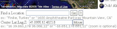
For now highlight the Center value and use the RMC-Copy to copy it. Select 36.2938,30.1497,14 (or your value) in the Map BlurbBit example above and use RMC-Paste to replace the value.
Click theicon to see the new map. Repeat the Add to an existing post steps above with another blog post.
Reload the Map of Blog Entries and notice the new location on the Blog map. All utilities which use extracted data will be automatically updated with the latest available data when they are used or reloaded.
There are various ways to find the lat/lng of a location/address, but only you know the details and zoom level you want to highlight with your map. The easiest way to find a location and adjust/prototype a BlurbBits location is through the BlurbBits Mapr. You can even save all the results to the scratchpad so you can easily modify or combine the data later.
Adding Online Photos
After SelectionBlogs and maps are great but a picture is worth a 1000 words. Adding photos can be a real pain especially if you add more than one or you try to add them into previous posts (like those published remotely).
w/Photos BeforeBlurbBits are designed to quickly add multiple photos to a blog post from online photo sharing sites and has advantages over traditional methods (including embedded slideshows). Online photos can be selected by a user, albums/sets, and/or a filtered by tags to match your blog post/entry content.
If you want to add your own photos, read the documentation for picasa or flickr photos and choose your filtering parameters (or use ours for now). Enter them in textbox above.
Click theicon to view your BlurbBit with the extracted photos. If the photos contain geotags, a Geo-Photos summary map will also appear. This map is dynamically extracted from data on the photo sharing site and therefore cannot be used to define the Blog post location within Blogger (without making the process unusably slow). Note: you can use the mapr to extract the position of your geotagged photos to use as LLZ parameter for a post. Mapped Picasa Albums build complete map/photo BlurbBits.
Add a Post Location Map to the Photos
Define the post location by appending &llz=36.2939,30.1496,14&mi=in (or another location) to the photo parameter textbox above. Click theicon to view the BlurbBit and notice the map which now appears along with the photo viewing options. When a BlurbBit is embedded on another website, we show a single highlight photo and wait to load the photos and map until the user selects a viewing option.
Select the Photo Strip menu button and then select a highlight photo (using the thumbnails) which best summarizes the collection of photos or the blog post topic you'll be writing about or adding the photos to.
Click i (info) in the top BlurbBit menu and add the BlurbBit to a post (refer to the section above if needed).
Note: The location definition MUST be added to photos in order to map the blog post in extracted utilities. The easiest way to accomplish both is to use the BlurbBits Mapr (with markers) to define the location and copy/paste the photo parameters into the extras textbox. If you use Picasa albums you can easily generate Mapped Picasa Albums.
BlurbBit Add Gadget

If the location you added is new, you'll also see it on the Extract a Map of Blog Posts BlurbBit above. You can use the Blogger Add Gadget publishing option to add this map to your sidebar. Make sure you read Gadget Overload post to understand the tradeoffs/options.
BlurbBit BlogThis
Now if you are deathly afraid of the HTML post editor or just want a quick way to create a new post for your BlurbBit, click the Blogger BlogThis button under the publishing options.

A Blog Your Bit popup will appear. If you are NOT already logged into Blogger, click the Login to access your Blogger account (you only need to do this once). Choose your Blog (if you have more than one) and then change the title, write the post text and add labels etc by following the notes above each section. The BlurbBit will replace the [BLURBBIT] tag, so feel free to add text before and/or after. Click Publish Post, the un-formatted blog will appear below as a preview. Select the link to navigate to the actual blog post (or view Our Sample result .. cheater).
If you only create new posts and are always connected to the internet when you blog, the BlogThis option is simplest solution for creating new blog posts with any BlurbBit (including photos, maps etc). We didn't start by showing you this option because we want you to be able to add BlurbBits to your posts using the post editor for existing posts and those posted remotely via email.
Remote Blogging
Did you know you can post blogs via email (moblogging)? It's great for keeping people updated, even from the middle of the ocean, and you don't get more remote than that!!
Most remote emailing systems (uuplus, winlink, skyfile) only support plain text emails, so HTML formatting is not supported. After you set up your Blogger account for posting via email, you should test that it is working by sending a simple test text (and optional attached photo) to your Mail-To-Blogger address (add 42 15.0N 70 52.9W to the email text to map it). Some remote email systems add end of line characters to outgoing mail so make sure you test it from your actual remote system before heading out (or your formatting will be terrible). You can also remove the additional text which gets appended to the end by some email systems, put
Overview
So now you know how to define a posts location, add photos, a map or both to an existing or new Blog post, extract a Blog map (into a BlurbBit), find a location to map, blog remotely AND add BlurbBits to the sidebar. We have two mapping options that highlight blog post location data which could effect how you choose to map your existing blog posts.
BlurbsViewr Interactive Maps
If you only want to create an interactive Blog map, append the Map of Blog Posts Blogger specific parameters to the BlurbsViewr (new window) (ie. ?blogger=svbillabong). You can change the number of posts shown and even filter post for a specific trip or area by adjusting the Blogger extraction parameters. A map icon will appear for each blog post with a defined location.
This is a great way to navigate your blog but some people don't like to use interactive maps (can you believe that?). Plus people who follow your blog through a RSS feed can't choose the sidebar Show Interactive Blog Map because the sidebar doesn't exist in the feed view.
Dynamic GeoBlog Maps
Dynamic GeoBlog maps are the most flexible way to show your post locations within Blogger. These maps are created on the fly based on the content of each page: A popup map is added to each post which contains a location, (including those posted via remote blogging emails) and a summary GeoBlogs on this Page map if GeoBlogs are found. These dynamic maps only work within Blogger, not the Blogger feeds.
Mapping Existing Blog Posts
The easiest way to map a Blog post is to extract the Blogger data into the BlurbBits Mapr by appending the Map of Blog Posts Blogger specific parameters to the Url BlurbBits Mapr (new window). If a post location is defined, a icon will appear next to the blog post title. Clicking on the list (or map marker) will center the map at the stored lat/lng location AND zoom of the post (if available). Posts with the
  icon have no defined location.
Use the mouse to highlight (don't click yet) an undefined blog post entry. If needed, use the preview window (to the right) to refresh your memory of the posts content.
Use the Finding a Location methods above and choose a zoom level you want to map. Make sure the LLZ (Lat,Long,Zoom) Locator is centered by clicking Move next to the Center Lat,Lng,Z: text box.
 Now select the post in the sidebar list and then click on the LLZ icon to set the posts location/zoom. While you are dragging the unplaced post marker, you can place it anywhere by clicking on the map (the BlurbBit will always center at the post location/zoom).
Once you have defined a blog post, you can preview it's BlurbBit Map by clicking the Preview BlurbBit button (for blog posts we suggest you disable the Use Label: toggle). You can add photos or customize the map (markers, paths etc) by adding parameters to the Extras textbox. Note: The first preview of a Object defines (and stores) the BlurbBit definition (within the Mapr), so make sure you set the Update toggle to make subsequent changes and unset it again before changing to a new post!!
NOTE: The BlurbBits Mapr does not modify your existing blog data so you need to add a BlurbBit to each blog post. The easiest way to edit a specific post is to click on the link in the preview and then click the Edit Post icon at the bottom.
If you plan on using Dynamic GeoBlog Maps and you don't like using a full map for each post, you can use the BlurbBit Add text link in Website/Blog publishing option (for maps only) and you'll get a popup map.
Now What?
Decision time: What do you want to do about all your old blog posts?
Obviously you could continue to map posts, generate BlurbBits and add them to each post you want to map (you don't HAVE to map them all). In fact, that's the only way you'll get a map within a Blogger post and provide support for feeds. If you have a small number of existing posts this might be the easiest cleanest way. Everyone will have access to a post map (including new or catchup readers)!! While you are adding the BlurbBits to define the location, you can also add new photos you feel would enhance your existing posts. Mapped Picasa Albums can also be created quickly with the Mapr.
Just the interactive map please
If you have 100's of posts but no one is reading the older ones and you aren't changing/editing them any more, we have a solution. We'll use the Mapr ScratchPad to save your data and then load it into the web based Google Spreadsheets to re-extract it. We'll also combine the older data with the latest additions from your Blogger feed. Note: Saving the data takes a snapshot of the blog posts in its current state, so subsequent changes to those posts will NOT be seen.
You don't need to map every post just to see a trail of where you've been. You can also draw lines in the BlurbBits mapr and combine it with blog posts using Google Spreadsheets command options or scratchpad data (try drawing a quick line)!! You can also combine your blog with another website using the Scratchpad/spreadsheet method.
Saving the Scratchpad
Switch to your blogs Mapr window (from above) and select Text Tab Delimited in the ScratchPad Format pulldown. Then click the Save To Scratchpad button. Use the RMC-Select All in the scratchpad window to select and then RMC-Copy to copy all the text. Open a new text document with Notepad (or a simple text editor) and paste the text. Save the document.
Using Published Google SpreadSheet (GSS)
Now you have a snapshot of your newly mapped posts, but we know you don't want to have to edit this file every time you add a new blog post. We'll use Extract Commands and our Blogger parameters to combine the two.
Follow these instructions to import your saved scratchpad file and publish it. Here's the example file.
Combine with latest Blogger data
The second row contains the extbb+ and our Blogger parameters (&blogger=BlogName:Number:Options) blogger=svbillabong:50:published-min=2008-10-30T10:18:00Z. The :50 specifies Number, a maximum of 50 posts. The :published.. field sets the minimum date Option so only posts dated after the specific date/time will be included. In order to succeed, the published-min must be set to return at least one post entry, otherwise a Nothing Found error will be returned.
Select the first row by clicking the 1 in the furthest left hand column. Use the RMC-Insert 1 Below button to add a new row. Add extbb+ to the first column and the correct Blogger extraction parameters, maximum post and published-min parameters to the second column (as above). If you publish frequently use 100 instead of 50. Make sure the date/time is between the first two posts (I add an hour to the second posts time).
Select the third row and use RMC-Delete Row to delete the first blog posts data. You may want to add a new test post to make sure it gets added correctly. Note: The bottom of this file also contains Lines for each years sailing track (L) and all our Picasa Albums (A) for our starting location.
The Full Monty
What's the best way to manage a travel blogs new posts? Our process varies slightly depending on how/where we publish our posts.
Via Email: We add our lat/lng location to the top of the Mail-to-Blogger email and sometimes attach a small photo (250 px max). We organize and edit our photos in Picasa (remotely) and then upload them when we get internet access. Then we use the Mapr to extract our recent Blog posts (and their text lat/lng data) to create a BlurbBit with a map (the minimum) or a map and photos that we've filtered to match the post (we also check and tweak the map zoom level). We add these new BlurbBits back into each post we published remotely (since the last time we had internet). Sometimes we create a new trip summary post and add an entire album to it (with our current location), you could even add your travel path (we update our KML file from our GPS)!!
Connected to Internet: We use the Mapr (with no Url parameters) to find our location. If we have more than a couple of photos, we combine them with the location Map and add our BlurbBit to the post or use BlogThis for a new one. For posts with single photos we use the standard post editors add image button. If we know our location, I just tweak the BlurbBit Url parameters using the interactive examples as a guide (yes I still need a manual).
Note: since we use the Dynamic GeoBlog maps we use the Add text link in Website/Blog Publishing Option to add a map only BlurbBit (you'll get a popup). However, since we've started using BlurbBits we always add photos to our map (it's almost too easy).
Migrating Existing Gadgets
You don't need to adjust your existing post photos (unless you want to). Check out our post on Gadget Overload for some hints, along with ways you can keep people up to date with your changes as you integrate BlurbBits into your blog.
Combining with other sites
We started out our travels with only a website. Then we started blogging so we could email from remote locations, but still kept our website going. Now we do much more in Blogger because it's so easy. We still update our site and manually map new page links (via the mapr scratchpad). The minimum data required is the TYPE,LLZ,LABEL,URL. DATE is necessary if you'll be sorting the results and DESC provides the preview text. Check out the scratchpad and the column details for more information. Make sure the columns match your Blogger ScratchPad data and copy/paste the new rows and add them to the top of your published Google Spreadsheet. Here's our combined file.
If you are using Blogger to track your travels (and why wouldn't you?), don't forget to add a "where" or tracking (or both) BlurbBit to your non-blog site. Use Map of Blog Posts parameters and/or add extracted map views (&mv=where&mi=in) to create a BlurbBit which shows your latest location and blog post (example).
Adjusting/Copying an Existing Blogger BlurbBit
Note: we highly recommend using the scratchpad to save complicated BlurbBits data.
Blogger currently changes the HTML code it publishes (ie. & becomes & amp;) which makes it hard to get back to the original BlurbBit URL. If the BlurbBit is simple just replace it with a new one, but if it is complex or you simply want to add or adjust parameters (and don't feel comfortable editing the raw HTML), use this Design Mode technique.
Edit the post/gadget HTML code and find the first blurbbits.html? within the begin-end of the BlurbBit. Add design=true& after the ?, this enables design mode. Publish the post (or save the gadget) and click the info button. Use the Paste link for email or IM path to get the original URL, adjust as needed.
Note: This Design mode adjustment can also be used if you want to allow users to be able to add your BlurbBit to their site.
If you use the Mapr, you can also save BlurbBit source data to the scratch pad which makes it easy to adjust travel paths etc later. You could also copy the iframe src= string (for embeded) or anchor href= string (for links) to a text editor, replace & amp; with &.
Note: The Dynamic GeoBlog maps are necessary to view these maps within your blog post. Nothing is added directly to your blog post and readers following your blog (RSS Feeds) will only see the lat/lng string. BlurbBits can be used to visualize these location maps within your blog post and easily add/manage online photos for all your readers and followers. Update: we've enhanced the functionality and can convert BlurbBit links into dynamic popups (maps and photos). Add the gadget via the link above and start adding the lat/lng text format to the posts you want mapped, it's the easiest way to get started. We've also added support for post summaries which can be used to optimize your blogs performance and improves traceability.
Stand Alone BlurbBit Examples
It is important to understand that there are two parts; the standalone BlurbBit which allows a map or online photos (and both) to be added to a specific blog post/entry (or sidebar) and the extracted data which can then displayed in various utilities. Note: The goal of this post is to define a process and NOT the details/options of each utility which is used, detailed documentation is available though the additional links provided.
Extracted BlurbBit Examples
We will document a complete process that supports an interactive blog navigation map AND uses BlurbBits for photos and maps within the blog. We also provide options for mapping existing posts. Note: This process can be used for any geo-referenced data (news, travel blogs, photo blogs) where maps and/or photos help clarify a specific post topic or location.
Define a Post/Entry Location
First lets start by adding a location to an existing Blog post. A Blog location can be defined by a BlurbBits Map or by lat/lng text for Blogger's mobile options.Basics: BlurbBits are created/customized via Url Parameters.
Map BlurbBit:
&llz=36.2938,30.1497,14&mi=in
A map BlurbBit with initial view zoomed in. Adjust the lat,lng,zoom parameter above if you feel comfortable (Map options)
Click the
icon above to see the resulting BlurbBit. Click i (info) in the top BlurbBit menu to see the publishing options (see example results/options in a single blog post). You can also try adding the lat/lng string (make sure it is a different location so you'll it).Add the BlurbBit to a Blog Post
Open a new Browser window, login to Blogger and create/edit a new post. Make sure the post editor is in Edit Html mode.
Go back to the BlurbBit info window and double click in the textbox under Embed in Website/Blog Entry (with feed) to highlight all the HTML code. Use a right mouse click (RMC)-Copy to copy the code, then switch to the Blogger editor window and RMC-Paste to paste it. Update: If you are using Dynamic GeoBlogs you can use the Add Text Link in Website/Blog option and we'll take care of the rest for you.
Notice that all the HTML code is contained within <!--BEGIN-BLURBBIT and END-BLURBBIT-->. Blog post text can be added before or after these BEGIN/END statements. If you want to change/delete the BlurbBit select all this HTML code and paste over it with the new HTML code or simply delete it.
Now publish your post and view your blog. The map you created should appear within your new post, if you have issues make sure you added the code in the Edit Html mode editor.
Extract a Map of Blog Entries:
That puts an quick map in your post but it also defines its location for other utilities. Before we go to far lets make sure we can extract the post location data. First find your BlogName or BlogId if you ftp publish your blog (parameters &blogger=BlogName:Number:Options)- BlogName is configurable portion of your Blogspot address
ex: use blurbbits for http://blurbbits.blogspot.com - BlogId is used to access the data for ftp published blogs
Create a new Post or Edit an existing post
you should see post-create.g?blogID=XXX or post-edit.g?blogID=xxx
ex: use the blogID value (XXX)
Note: by default we only extract the last 10 entries, use the :Number parameter to extract more.
&blogger=svbillabong&width=220&height=200
A Blogger map for svbillabong.blogspot.com&bloggerid=13526182&width=220&height=200
The same map accessed via BlogIdAdjust the example above to your BlogName (or BlogId) and click the
icon to see the resulting BlurbBit map which is extracted from your blog. If a map does not appear check the Blogger extraction options and make sure your RSS feed and Blogger parameters are setup correctly.A single blog post on a map is a little boring so lets find some more locations to add to another posts. Note: At this point you've done the basics, which allows you to map your blog posts and re-extract them into the other utilties (the blogger=xxx parameters can also be added to the BlurbsViewr and BlurbBits Mapr). The following are options which help you find your location, easily add photos and explain other utilties and viewing ideas. We'll also give you some options for your historical blogs and new post published via Mobile Options.
Finding a Location
Open the BlurbBits Mapr (new window). The map should center near your current location (it may use your internet service providers location or start at 0,0).
Basics: The BlurbBits setup map is designed around a right mouse click (RMC) context menu.
You can either:
- Drag the map around to find an exact location
- Enter your location in the Find a Location text box and click Go.
- Enter your Lat/Lng in the Center Lat,Lng,Z: text box and click Move.
For now highlight the Center value and use the RMC-Copy to copy it. Select 36.2938,30.1497,14 (or your value) in the Map BlurbBit example above and use RMC-Paste to replace the value.
Click the
icon to see the new map. Repeat the Add to an existing post steps above with another blog post.Reload the Map of Blog Entries and notice the new location on the Blog map. All utilities which use extracted data will be automatically updated with the latest available data when they are used or reloaded.
There are various ways to find the lat/lng of a location/address, but only you know the details and zoom level you want to highlight with your map. The easiest way to find a location and adjust/prototype a BlurbBits location is through the BlurbBits Mapr. You can even save all the results to the scratchpad so you can easily modify or combine the data later.
Adding Online Photos
After Selection
w/Photos Before
&picasa=SailBillabong:Sailing2007
A Picasa Album&flickr=25998359@N07:set=72157607010384141
A Flickr Set (use &flickrgeo for geotagged photos)If you want to add your own photos, read the documentation for picasa or flickr photos and choose your filtering parameters (or use ours for now). Enter them in textbox above.
Click the
icon to view your BlurbBit with the extracted photos. If the photos contain geotags, a Geo-Photos summary map will also appear. This map is dynamically extracted from data on the photo sharing site and therefore cannot be used to define the Blog post location within Blogger (without making the process unusably slow). Note: you can use the mapr to extract the position of your geotagged photos to use as LLZ parameter for a post. Mapped Picasa Albums build complete map/photo BlurbBits.Add a Post Location Map to the Photos
Define the post location by appending &llz=36.2939,30.1496,14&mi=in (or another location) to the photo parameter textbox above. Click the
icon to view the BlurbBit and notice the map which now appears along with the photo viewing options. When a BlurbBit is embedded on another website, we show a single highlight photo and wait to load the photos and map until the user selects a viewing option.Select the Photo Strip menu button and then select a highlight photo (using the thumbnails) which best summarizes the collection of photos or the blog post topic you'll be writing about or adding the photos to.
Click i (info) in the top BlurbBit menu and add the BlurbBit to a post (refer to the section above if needed).
Note: The location definition MUST be added to photos in order to map the blog post in extracted utilities. The easiest way to accomplish both is to use the BlurbBits Mapr (with markers) to define the location and copy/paste the photo parameters into the extras textbox. If you use Picasa albums you can easily generate Mapped Picasa Albums.
BlurbBit Add Gadget
If the location you added is new, you'll also see it on the Extract a Map of Blog Posts BlurbBit above. You can use the Blogger Add Gadget publishing option to add this map to your sidebar. Make sure you read Gadget Overload post to understand the tradeoffs/options.
BlurbBit BlogThis
Now if you are deathly afraid of the HTML post editor or just want a quick way to create a new post for your BlurbBit, click the Blogger BlogThis button under the publishing options.
A Blog Your Bit popup will appear. If you are NOT already logged into Blogger, click the Login to access your Blogger account (you only need to do this once). Choose your Blog (if you have more than one) and then change the title, write the post text and add labels etc by following the notes above each section. The BlurbBit will replace the [BLURBBIT] tag, so feel free to add text before and/or after. Click Publish Post, the un-formatted blog will appear below as a preview. Select the link to navigate to the actual blog post (or view Our Sample result .. cheater).
If you only create new posts and are always connected to the internet when you blog, the BlogThis option is simplest solution for creating new blog posts with any BlurbBit (including photos, maps etc). We didn't start by showing you this option because we want you to be able to add BlurbBits to your posts using the post editor for existing posts and those posted remotely via email.
Remote Blogging
Did you know you can post blogs via email (moblogging)? It's great for keeping people updated, even from the middle of the ocean, and you don't get more remote than that!!
Most remote emailing systems (uuplus, winlink, skyfile) only support plain text emails, so HTML formatting is not supported. After you set up your Blogger account for posting via email, you should test that it is working by sending a simple test text (and optional attached photo) to your Mail-To-Blogger address (add 42 15.0N 70 52.9W to the email text to map it). Some remote email systems add end of line characters to outgoing mail so make sure you test it from your actual remote system before heading out (or your formatting will be terrible). You can also remove the additional text which gets appended to the end by some email systems, put
#end at the end of your post. With skyfile, adjusting the email editting window size changes the location of the end of line characters.Overview
So now you know how to define a posts location, add photos, a map or both to an existing or new Blog post, extract a Blog map (into a BlurbBit), find a location to map, blog remotely AND add BlurbBits to the sidebar. We have two mapping options that highlight blog post location data which could effect how you choose to map your existing blog posts.
BlurbsViewr Interactive Maps
If you only want to create an interactive Blog map, append the Map of Blog Posts Blogger specific parameters to the BlurbsViewr (new window) (ie. ?blogger=svbillabong). You can change the number of posts shown and even filter post for a specific trip or area by adjusting the Blogger extraction parameters. A map icon will appear for each blog post with a defined location.
This is a great way to navigate your blog but some people don't like to use interactive maps (can you believe that?). Plus people who follow your blog through a RSS feed can't choose the sidebar
Show Interactive Blog Map because the sidebar doesn't exist in the feed view.Dynamic GeoBlog Maps
Dynamic GeoBlog maps are the most flexible way to show your post locations within Blogger. These maps are created on the fly based on the content of each page: A popup map is added to each post which contains a location, (including those posted via remote blogging emails) and a summary GeoBlogs on this Page map if GeoBlogs are found. These dynamic maps only work within Blogger, not the Blogger feeds.
Mapping Existing Blog Posts
The easiest way to map a Blog post is to extract the Blogger data into the BlurbBits Mapr by appending the Map of Blog Posts Blogger specific parameters to the Url BlurbBits Mapr (new window). If a post location is defined, a
icon will appear next to the blog post title. Clicking on the list (or map marker) will center the map at the stored lat/lng location AND zoom of the post (if available). Posts with the icon have no defined location.Use the mouse to highlight (don't click yet) an undefined blog post entry. If needed, use the preview window (to the right) to refresh your memory of the posts content.
Use the Finding a Location methods above and choose a zoom level you want to map. Make sure the LLZ (Lat,Long,Zoom) Locator is centered by clicking Move next to the Center Lat,Lng,Z: text box.
Now select the post in the sidebar list and then click on the LLZ icon to set the posts location/zoom. While you are dragging the unplaced post marker, you can place it anywhere by clicking on the map (the BlurbBit will always center at the post location/zoom).Once you have defined a blog post, you can preview it's BlurbBit Map by clicking the Preview BlurbBit button (for blog posts we suggest you disable the Use Label: toggle). You can add photos or customize the map (markers, paths etc) by adding parameters to the Extras textbox. Note: The first preview of a Object defines (and stores) the BlurbBit definition (within the Mapr), so make sure you set the Update toggle to make subsequent changes and unset it again before changing to a new post!!
NOTE: The BlurbBits Mapr does not modify your existing blog data so you need to add a BlurbBit to each blog post. The easiest way to edit a specific post is to click on the link in the preview and then click the Edit Post icon
at the bottom.If you plan on using Dynamic GeoBlog Maps and you don't like using a full map for each post, you can use the BlurbBit Add text link in Website/Blog publishing option (for maps only) and you'll get a popup map.
Now What?
Decision time: What do you want to do about all your old blog posts?
Obviously you could continue to map posts, generate BlurbBits and add them to each post you want to map (you don't HAVE to map them all). In fact, that's the only way you'll get a map within a Blogger post and provide support for feeds. If you have a small number of existing posts this might be the easiest cleanest way. Everyone will have access to a post map (including new or catchup readers)!! While you are adding the BlurbBits to define the location, you can also add new photos you feel would enhance your existing posts. Mapped Picasa Albums can also be created quickly with the Mapr.
Just the interactive map please
If you have 100's of posts but no one is reading the older ones and you aren't changing/editing them any more, we have a solution. We'll use the Mapr ScratchPad to save your data and then load it into the web based Google Spreadsheets to re-extract it. We'll also combine the older data with the latest additions from your Blogger feed. Note: Saving the data takes a snapshot of the blog posts in its current state, so subsequent changes to those posts will NOT be seen.
You don't need to map every post just to see a trail of where you've been. You can also draw lines in the BlurbBits mapr and combine it with blog posts using Google Spreadsheets command options or scratchpad data (try drawing a quick line)!! You can also combine your blog with another website using the Scratchpad/spreadsheet method.
Saving the Scratchpad
Switch to your blogs Mapr window (from above) and select Text Tab Delimited in the ScratchPad Format pulldown. Then click the Save To Scratchpad button. Use the RMC-Select All in the scratchpad window to select and then RMC-Copy to copy all the text. Open a new text document with Notepad (or a simple text editor) and paste the text. Save the document.
Using Published Google SpreadSheet (GSS)
Now you have a snapshot of your newly mapped posts, but we know you don't want to have to edit this file every time you add a new blog post. We'll use Extract Commands and our Blogger parameters to combine the two.
Follow these instructions to import your saved scratchpad file and publish it. Here's the example file.
Combine with latest Blogger data
The second row contains the extbb+ and our Blogger parameters (&blogger=BlogName:Number:Options) blogger=svbillabong:50:published-min=2008-10-30T10:18:00Z. The :50 specifies Number, a maximum of 50 posts. The :published.. field sets the minimum date Option so only posts dated after the specific date/time will be included. In order to succeed, the published-min must be set to return at least one post entry, otherwise a Nothing Found error will be returned.
Select the first row by clicking the 1 in the furthest left hand column. Use the RMC-Insert 1 Below button to add a new row. Add extbb+ to the first column and the correct Blogger extraction parameters, maximum post and published-min parameters to the second column (as above). If you publish frequently use 100 instead of 50. Make sure the date/time is between the first two posts (I add an hour to the second posts time).
Select the third row and use RMC-Delete Row to delete the first blog posts data. You may want to add a new test post to make sure it gets added correctly. Note: The bottom of this file also contains Lines for each years sailing track (L) and all our Picasa Albums (A) for our starting location.
The Full Monty
What's the best way to manage a travel blogs new posts? Our process varies slightly depending on how/where we publish our posts.
Via Email: We add our lat/lng location to the top of the Mail-to-Blogger email and sometimes attach a small photo (250 px max). We organize and edit our photos in Picasa (remotely) and then upload them when we get internet access. Then we use the Mapr to extract our recent Blog posts (and their text lat/lng data) to create a BlurbBit with a map (the minimum) or a map and photos that we've filtered to match the post (we also check and tweak the map zoom level). We add these new BlurbBits back into each post we published remotely (since the last time we had internet). Sometimes we create a new trip summary post and add an entire album to it (with our current location), you could even add your travel path (we update our KML file from our GPS)!!
Connected to Internet: We use the Mapr (with no Url parameters) to find our location. If we have more than a couple of photos, we combine them with the location Map and add our BlurbBit to the post or use BlogThis for a new one. For posts with single photos we use the standard post editors add image button. If we know our location, I just tweak the BlurbBit Url parameters using the interactive examples as a guide (yes I still need a manual).
Note: since we use the Dynamic GeoBlog maps we use the Add text link in Website/Blog Publishing Option to add a map only BlurbBit (you'll get a popup). However, since we've started using BlurbBits we always add photos to our map (it's almost too easy).
Migrating Existing Gadgets
You don't need to adjust your existing post photos (unless you want to). Check out our post on Gadget Overload for some hints, along with ways you can keep people up to date with your changes as you integrate BlurbBits into your blog.
Combining with other sites
We started out our travels with only a website. Then we started blogging so we could email from remote locations, but still kept our website going. Now we do much more in Blogger because it's so easy. We still update our site and manually map new page links (via the mapr scratchpad). The minimum data required is the TYPE,LLZ,LABEL,URL. DATE is necessary if you'll be sorting the results and DESC provides the preview text. Check out the scratchpad and the column details for more information. Make sure the columns match your Blogger ScratchPad data and copy/paste the new rows and add them to the top of your published Google Spreadsheet. Here's our combined file.
If you are using Blogger to track your travels (and why wouldn't you?), don't forget to add a "where" or tracking (or both) BlurbBit to your non-blog site. Use Map of Blog Posts parameters and/or add extracted map views (&mv=where&mi=in) to create a BlurbBit which shows your latest location and blog post (example).
Adjusting/Copying an Existing Blogger BlurbBit
Note: we highly recommend using the scratchpad to save complicated BlurbBits data.
Blogger currently changes the HTML code it publishes (ie. & becomes & amp;) which makes it hard to get back to the original BlurbBit URL. If the BlurbBit is simple just replace it with a new one, but if it is complex or you simply want to add or adjust parameters (and don't feel comfortable editing the raw HTML), use this Design Mode technique.
Edit the post/gadget HTML code and find the first blurbbits.html? within the begin-end of the BlurbBit. Add design=true& after the ?, this enables design mode. Publish the post (or save the gadget) and click the info button. Use the Paste link for email or IM path to get the original URL, adjust as needed.
Note: This Design mode adjustment can also be used if you want to allow users to be able to add your BlurbBit to their site.
If you use the Mapr, you can also save BlurbBit source data to the scratch pad which makes it easy to adjust travel paths etc later. You could also copy the iframe src= string (for embeded) or anchor href= string (for links) to a text editor, replace & amp; with &.
Subscribe to:
Posts (Atom)